An intelligent air-ground integrated system combining a UAV swarm, unmanned ground vehicle, and six-axis robotic
arm for target search, pursuit, tracking, and final grasping.
Built on autonomous and controllable hardware and software platforms, the system creates a closed-loop workflow
from aerial search and intelligent pursuit to ground navigation and precision manipulation.
Closed-loop coordination from aerial discovery to ground grasping.
Rapidly finding targets, tracking them stably, and grasping them safely are common challenges in public safety,
emergency rescue, industrial inspection, and complex field operations. This solution connects aerial perception
and ground execution into one collaborative task chain.
Three UAVs search and pursue the target from the air, while the ground vehicle navigates toward the target area.
The onboard depth camera and robotic arm then complete local recognition, 3D positioning, grasp-pose calculation,
and stable pickup.
System Architecture
Airborne swarm layer, ground execution layer, and command collaboration layer.
01
Airborne Swarm Layer
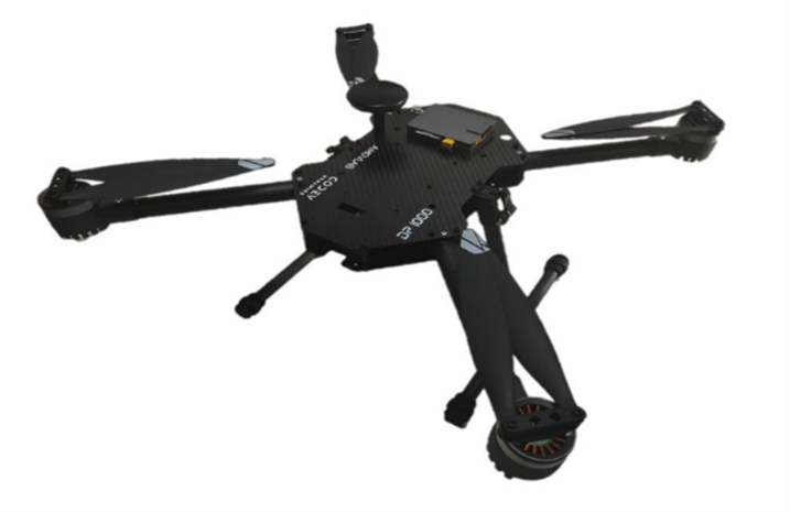
Three quadrotor UAVs based on the JCV-600 platform serve as the aerial swarm units. Each aircraft can carry a
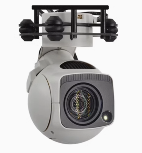
data link, RTK positioning module, onboard edge computer, and zoom gimbal camera for coverage, observation, and
local intelligent processing.
02
Ground Execution Layer
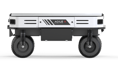
A RANGER MINI 2.0 UGV chassis and RM65-B six-axis robotic arm handle mobility, target approach, and final
grasping. The UGV performs navigation in the global coordinate system, while the arm completes fine operation
in the local coordinate system.
03
Command and Collaboration Layer
The ground station monitors UAV and UGV position, attitude, battery level, and operating status; displays
multi-UAV tracks and mission areas; supports takeoff, landing, route issuing, mission parameter adjustment, and
abnormal-state warnings.
Key Hardware and Software Capabilities
High-bandwidth communication, centimeter-level positioning, multimodal vision, and edge AI computing.
JCV-600 UAV Platform
600 mm wheelbase medium UAV frame with stable structure and rich expansion interfaces.
About 2.4 kg aircraft weight including battery; 4 kg maximum takeoff weight; 1.5 kg maximum payload.
About 70 min unloaded endurance in ideal conditions; about 35 min with a 1.5 kg payload.
Maximum speed about 45 km/h in Position mode and 80 km/h in Sport mode.
Four hub servo motors support in-place rotation, serpentine movement, and Ackermann steering.
Maximum speed about 2.6 m/s, vehicle weight about 135 kg, and payload capacity about 150 kg.
Maximum obstacle height about 100 mm and maximum climbing capability about 10 deg.
Typical endurance about 7 h; charging time about 1.5 h.
Optional solid-state LiDAR, depth camera, IMU, and other sensors.
RM65-B Six-Axis Robotic Arm
Body weight about 7.2 kg with 5 kg effective payload.
Maximum working radius about 610 mm.
Repeat positioning accuracy up to +/-0.05 mm.
IP54 protection rating.
Supports graphical programming, offline simulation, ROS, MoveIt, and other open-source stacks.
Communication and RTK Positioning
Dedicated data links and M15 RTK positioning provide the shared coordinate foundation for air-ground
collaboration. The LQ link supports the 2.4 GHz band, IEEE 802.11n WLAN, about 40 Mbps bandwidth, less than 3 ms
minimum latency, and up to 3 km transmission distance in ideal conditions. The RTK module supports BDS, GPS,
GLONASS, and QZSS, with centimeter-level positioning and up to 20 Hz data update rate.
Multimodal Visual Perception
The GX40 three-axis zoom gimbal camera supports 8.29 MP imaging, 10x optical zoom, up to about 40x with digital
zoom, 4K network video output, and laser illumination for low-light observation. A RealSense D435i depth camera
supports global shutter imaging, wide field of view, about 10 m measurement range, 1280 x 720 depth at up to 90
FPS, and RGB output up to 1280 x 1080 at 30 FPS.
Edge AI Computing
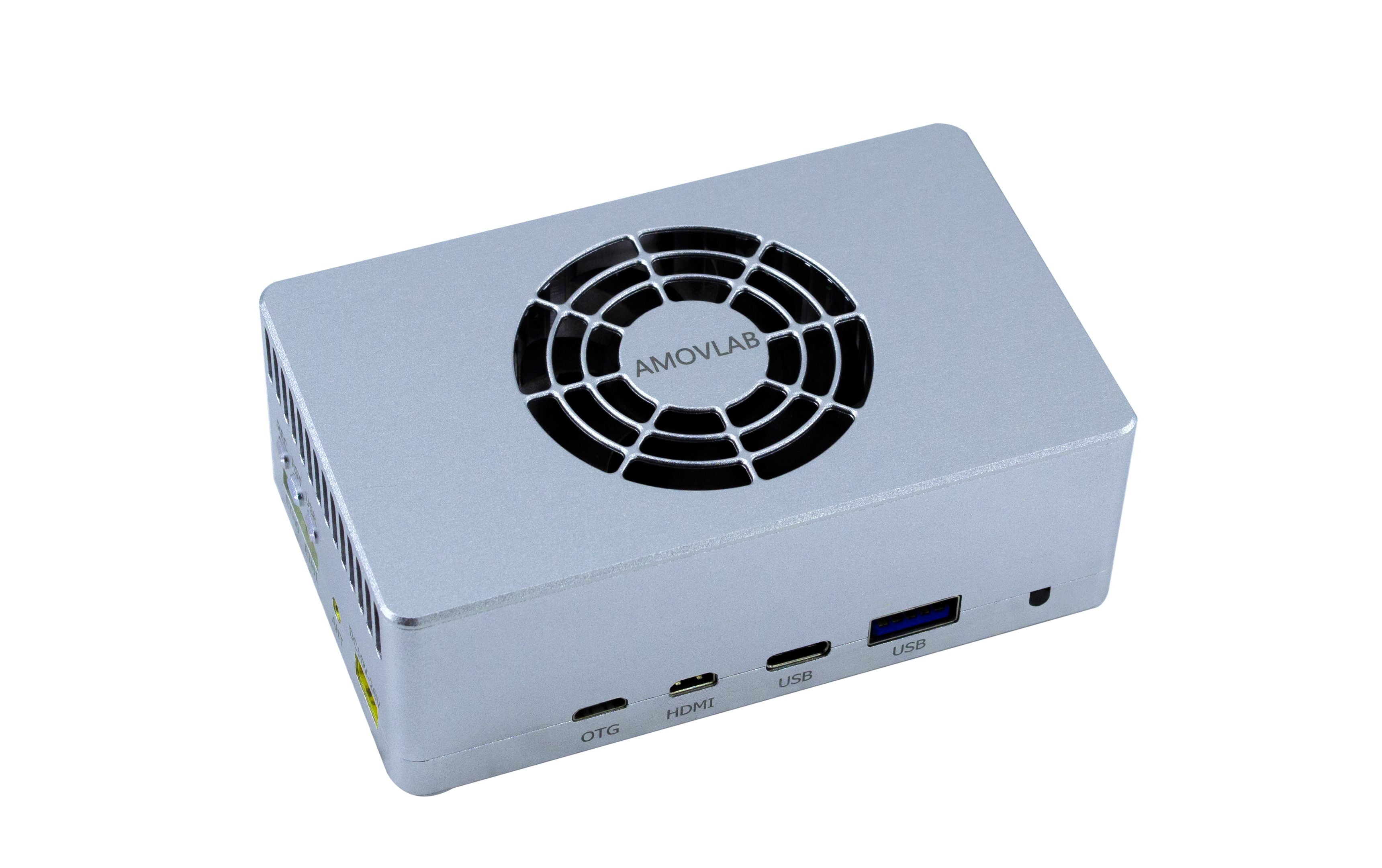
Airborne and ground platforms can carry an AllSpark2-Orin NX edge computing unit with NVIDIA Jetson Orin NX,
up to 100 TOPS AI performance, 1024-core Ampere GPU, 8-core Cortex-A78AE CPU, M.2 NVMe SSD support, and rich
CSI, Ethernet, USB, CAN, UART, and I2C interfaces.
Mission Workflow
From swarm area search to target pursuit and air-ground grasping.
01
Swarm Area Search
The operator selects a rectangular search area on the ground-station map. The mission is issued to the UAV
swarm, and each UAV plans and executes search routes according to area partitioning, aircraft state, and
distributed strategy.
02
Target Recognition and Pursuit
Vision and AI modules continuously detect and recognize targets. After a target is locked, the UAV records its
trajectory, predicts the possible path, and broadcasts the result so other UAVs can plan pursuit positions and
form a cooperative enclosure.
03
Air-Ground Grasping
Target position and status are sent to the UGV. The UGV navigates to the area while using LiDAR and vision for
path planning and obstacle avoidance. The depth camera and arm-end vision locate the target, compute the grasp
pose, and complete stable pickup.
Application Value
A comprehensive platform for swarm control, air-ground coordination, intelligent perception, and precision operation.
Complete Architecture
Covers aerial search, trajectory prediction, ground approach, and final grasping for system-level verification and comparative research.
Clear Modularity
UAVs, UGVs, robotic arms, data links, RTK positioning, and computing units can be replaced or expanded for secondary development.
Algorithm Friendly
Suitable for experiments in swarm collaborative control, path planning, target recognition, tracking, and air-ground cooperative control.
Scenario Adaptable
UAV count, sensors, and software stack can be adjusted for teaching experiments, complex scenario validation, and industry-oriented research.
Please review AMOVLAB's published policies before submitting product inquiries or placing an order. Policy details are available from the footer links and checkout flow.